| Play/Download Games [8] |
| Technology Gadgets [42] |
| World type Pichers [16] |
| Make Money Online [29] |
| From Editor Desk [33] |
|
Online Dating
[3]
Free online dating for singles around the world.
|
| Arts & Entertainment [17] |
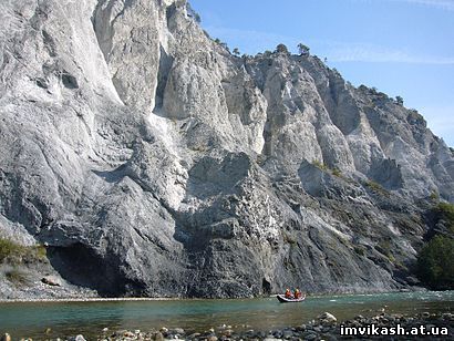
7:02:35 PM Flims Rockslide | |
The Flims Rockslide is the biggest landslide known to have occurred in the Alps. The effect of the slide is still widely visible today. It moved some 12 km3 (2.9 cu mi) of rock. The top of the slide can be found at 2,700 meters (8,858 ft) above sea level north of Flims at Mount Fil de Cassons. The fallen rock is limestone dating from the Mesozoic, including Mergel. The angle of slide is only 20-25 degrees. The falling debris formed a dam on the Vorderrhein River and created a lake in the Ilanz area. The river Rhine eventually crossed the debris field in an area named Ruinaulta. A geologist named Clemens Augenstein performed a collection of tests at the site. He studied sediment found embedded in the limestone dust. Using carbon dating, the limestone dust was found to be 10,055 years old (plus/minus 195 years). This puts the slide around 8000 BCE. A second source of identification was found in the wood discovered inside the debris, some 2 miles (3.2 km) upstream of the mouth of river Rabiusa. The wood was identified as coming from the Fil de Cassons area. Tests confirmed a carbon date of approximately 10,000 years. After the Flims Rockslide, most of the water escaped through the upper section of the debris. The event created rivers and lakes that have been gradually disappearing. One example is a lake named Caumasee, which is near Flims, in the Grisons, Switzerland. The lake is located in a huge forest and the water level varies according to underground flow. The landslide forced the river Rhine to create the Ruinaulta canyon and shaped the huge forest land surrounding Flims. The area is a haven for wildlife and is protected by cliffs several hundred meters high. The structures are beautiful and accessible by Rhaetian Railways. The destination is a popular place for rafting. | |
|
| |
| Total comments: 0 | |